

Request to install a hydrometric measuring station on the lake
A resolution for the installation of a hydrometric measuring station was unanimously adopted during the annual meeting and a request to send a letter (prepared by the committee) to Minister Benoit Charette was sent on July 22, 2022 to the municipalities.
Reports below by Michael Lukyniuk
Note: Mr. Lukyniuk is an Association volunteer who devotes his personal time to regularly monitoring the water levels of Grand Lac Rond. He reports his follow-up to the Center Expertise Hydrique du Québec, the organization responsible for managing the Hubert Tremblay dam at Lake 31 Milles, located upstream from our lake. Mr. Lukyniuk is not responsible for any decision taken by the Center that could have an impact on the water level of Grand Lac Rond.
Reports 2022
Sept 15 2022 (click to see the report)
Since my last report on September 4, the water level of Grand Lac Rond has increased by 3 cm. The reason for this change is due to the discharge of the dam at Lac des 31 Milles and the precipitation (25 mm). The water level of Grand Lac Rond is (pleasantly) high for this time of year but it is very stable. Here are the comparisons with past years:
September 14, 2022 - 147.36 m
September 12, 2021 - 147.00 m
September 12, 2020 - 147.18m
September 13, 2019 - 146.90m
September 14, 2018 - 147.21 m
September 15, 2017 - 147.26m
September 10, 2016 - 147.06 m
September 11, 2015 - 147.39 m
September 17, 2014 - 147.07 m
September 15, 2012 - 147.03 m
September 10, 2011 - 146.79 m
September 19, 2010 - 147.20m
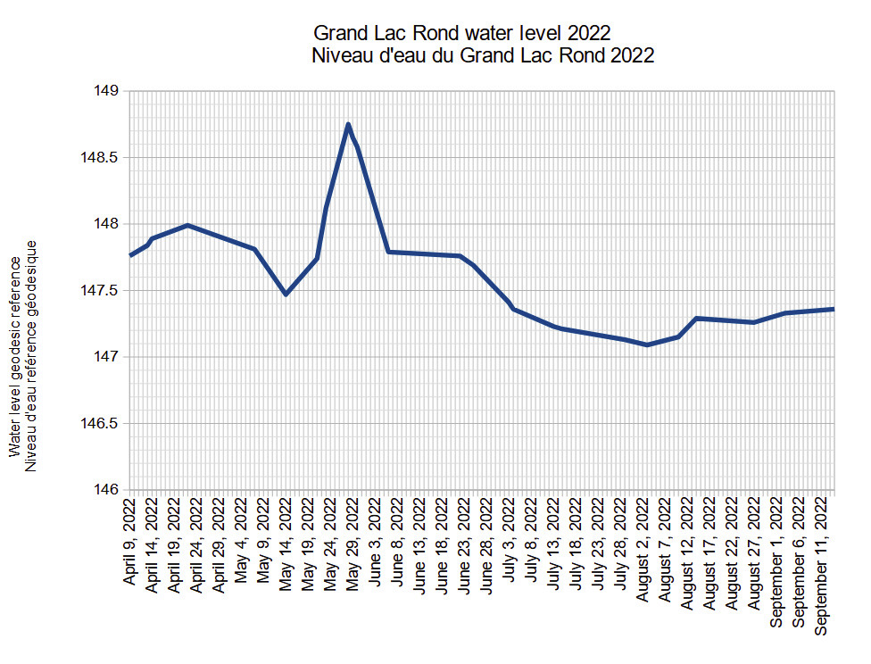
Sept 5, 2022 (click to see the report)
Since my last report on August 28, the water level of Grand Lac Rond has increased by 7 cm. The water level is pleasantly high but stable. The reason for this situation is due to the precipitation and the discharge of the dam at Lac des 31 Milles (an annual operation to promote fresh lake trout).
When we compare the water level of Grand Lac Rond with previous years, it is pleasantly high for this time of year:
• September 3, 2022 - 147.33m
• September 1, 2021 - 146.97m
• September 6, 2020 - 147.25m
• September 2, 2019 - 146.91m
• September 3, 2018 - 147.19m
• September 2, 2017 - 147.13m
• September 3, 2015 - 147.42m
• September 4, 2014 - 147.11m
• September 1, 2013 - 146.91m
• September 2, 2012 - 146.88m
August 14, 2022 (click to see the report)
Since my last report on August 11, the water level of Grand Lac Rond has increased by 14 cm (5.5 inches) due solely to the discharge of the Hubert-Tremblay dam at Lac des 31 Milles (because there was no precipitation during this period). Lac des 31 Milles decreased by 4 cm during this period (which is another demonstration of the strong effect of the discharge from upstream). Fortunately for Grand Lac Rond, this flow came during a time when water levels normally drop due to a lack of precipitation and drainage in the Gatineau River.
The water level of Grand Lac Rond is pleasantly high when compared to the same period in previous years:
August 14, 2022 - 147.29 m
August 15, 2021 - 147.10 m
August 09, 2020 - 147.23 m
August 15, 2019 - 147.00 m
August 14, 2018 - 147.21 m
August 14, 2017 - 147.13 m
August 17, 2016 - 147.10 m
August 15, 2015 - 147.16 m
August 11, 2014 - 146.91 m
August 14, 2013 - 146.92 m
August 11, 2012 - 146.89 m
August 14, 2011 - 146.88 m
August 11, 2022 (click here to see the report)
Since my last report on August 3, the water level of Grand Lac Rond has risen 6 cm due to the heavy precipitation the region has had (87 mm during this period). The water level of Lac des 31 Milles also rose by 9 cm, even more than Grand Lac Rond. I suspect the difference is due to the fact that Grand Lac Rond does not have the ability to prevent its water from draining into the Gatineau River while Lac des 31 Milles has a dam to control its water level.
The water level of Grand Lac Rond is within the means for this time of year thanks to the heavy precipitation lately and thanks to the changes to the operation of the dam which is starting to lower the water level of Lac des 31 Milles. at the beginning of August to promote lake trout spawning and which also helps to stabilize the water level of Grand Lac Rond at the time of the year when it is most needed. Here is a comparison of the water levels at Grand Lac Rond for this period:
August 10, 2022 - 147.15m
August 15, 2021 - 147.10 m
August 09, 2020 - 147.23 m
August 11, 2019 - 147.05 m
August 09, 2018 - 147.23m
August 10, 2017 - 147.21 m
August 10, 2016 - 147.03 m
August 08, 2015 - 147.12 m
August 11, 2014 - 146.91 m
August 07, 2013 - 146.94 m
August 11, 2012 - 146.89 m
August 07, 2011 - 146.88 m
August 3, 2022 (click here to see the report)
Since my last report on July 29, the water level of Grand Lac Rond has decreased by 4 cm. The water level is comparably low when compared to past years:
August 03, 2022 - 147.09 m
July 31, 2021 - 147.28 m
August 06, 2020 - 147.21 m
August 03, 2019 - 147.28 m
August 03, 2018 - 147.16 m
August 02, 2017 - 147.22 m
August 07, 2016 - 147.06 m

The reason for the low water level is certainly due to the lack of precipitation and the drainage of lake water into the Gatineau River. In the month of July, we had only 28 mm of precipitation (compared to 2021 it was 95 mm; in 2020 it was 118 mm; and in 2019 it was 84 mm). Without the constant flow of the Lac 31 Milles dam, the water level would have been much lower. Fortunately, this flow should continue throughout the months of August and September as part of the operation of the dam to lower the water level of Lac des 31 Milles to encourage fresh lake trout. Nevertheless, the water level of Grand Lac Rond is low and if it continues to be so, it will have negative impacts on the shoreline, aquatic plants and warmer water temperatures in the shallow regions of the lake (examples, Paul's Bay, the Narrows, and Paul's Beach). Unfortunately, this is not a new concern, it is an ongoing issue that has never been resolved.
July 29, 2022 (click to see the report)
Since my last report on July 16, the water level of Grand Lac Rond has decreased by 8 cm. During this period, there was not much precipitation but there was a constant discharge from the dam to Lac des 31 Milles. The water level of Lac des 31 Milles decreased by 7 cm during this period. This discharge has certainly helped to stabilize the water level of Grand Lac Rond. Without this discharge, the Grand Lac Rond would have lost large amounts of water flowing into the Gatineau River through the creek from the west of the lake.
In the days to follow, the operation of the dam at Lac des 31 Milles should continue to evacuate water in order to prepare for the operation to promote the freshness of the lake trout at Lac des 31 Milles. This operation certainly helps the Grand Lac Rond to stabilize its water level during the usually dry and hot days of August and September.
When we compare the water level of Grand Lac Rond with previous years, it is within the means for this time of year:
July 29, 2022 - 147.13 m
July 31, 2021 - 147.28 m
July 30, 2020 - 147.08 m
July 31, 2019 - 147.39 m
July 28, 2018 - 147.14 m
July 30, 2017 - 147.26m
July 31, 2016 - 147.06 m
July 29, 2015 - 147.15m
July 29, 2014 - 146.98m
July 26, 2013 - 147.11m
July 28, 2012 - 146.88 m
July 31, 2011 - 146.94m
July 16, 2022 (click to see the report)
Since my last report on July 5, the water level of Grand Lac Rond has decreased by 15 cm (5 inches). We did not have much precipitation during this period and the discharge from the dam was limited. But when we compare the water level with the past year, it is about average for this period:
July 16, 2022 - 147.21 m
July 17, 2021 - 147.36 m
July 18, 2020 - 146.98 m
July 14, 2019 - 147.35m
July 16, 2018 - 147.19 m
July 15, 2017 - 147.62m
July 17, 2016 - 147.01m
July 17, 2015 - 147.01 m
July 16, 2014 - 147.19 m
July 14, 2013 - 147.40m
July 14, 2012 - 146.82 m
I notice that the water level is dropping faster lately, but with the precipitation forecast I believe (hope) the lake remains stable.
July 7, 2022 (click to see the report)
Since my last report on June 26, the water level of Grand Lac Rond has dropped by 33 cm (13 inches). This is good news and a big change considering all the precipitation that has fallen over the past week (29mm). I believe the change is attributable to the lower water level of the Gatineau River which has now allowed the discharge of water from Grand Lac Rond.
The water level continues to drop rapidly (I calculate about 5cm per day), but it is at a slightly high water level for this time of year when compared to previous years:
July 4, 2022 - 147.36 m
July 1, 2021 - 147.18 m
July 6, 2020 - 146.97m
July 4, 2019 - 147.54 m (the year of heavy flooding)
July 6, 2018 - 147.37m
July 7, 2017 - 147.60 m (the year of heavy flooding)
July 5, 2016 - 146.94m
July 4, 2015 - 147.02 m
July 5, 2014 - 147.11m
July 8, 2013 - 147.54m
July 7, 2012 - 146.85m
July 3, 2011 - 147.26 m
In my report (attached), I have included an analysis of the water level situation in the month of June as follows:
Within a week at the start of the month, the water level dropped dramatically by 79 cm (31 inches), but remained extremely high for the rest of the month. In fact, the water level was at the same level during the April spring flood! On June 25, when I took my measurement, the water level was about 55 cm (21 inches) higher than normal for this time of year. (In comparison, the water level at Lac des 31 Milles was 9 cm (3.5 inches) higher than normal for this time of year.) The flooding that occurred from April to end of June was significantly worse than the flooding that occurred in 2017 and 2019. It is mainly attributable to the high level of the Gatineau River (which prevented water from coming out of Grand Lac Rond). (Note: Rainfall in May and June 2022 was normal at 180mm. For the same months in 2021 it was 204mm, in 2020 136mm and in 2019 217mm. The other possible factor affecting the level of water from Le Grand Lac Rond is the discharge from the dam on Lac des 31 Milles, but the CEHQ held back large quantities from coming down in May but carefully released quantities in June.) The effect of the flood on the Grand Lac Rond was severe - debris was seen around the shore, septic tanks were flooded, docks were damaged and the lake water quality was poor.
Finally, I must mention that at the annual meeting of the Grand Lac Rond lake association on July 3, there was a good discussion on the situation of the water level on the lake. Members were discouraged by the level of flooding that occurred this year and the general water level instability over the past two decades.
June 26, 2022
Since my last report on June 6, the water level of Grand Lac Rond has dropped by 8 cm. The water level is still very high, indeed it is around the same water levels that we experienced in April when the spring floods started. The water level is at 147.69 m - the highest I have measured for this time of year in the 13 years that I have measured the water level of the lake! It is about 55cm (21 inches) higher than you would normally expect at this time of year. By comparison, Lac des 31 Milles is currently 162.24 m - 9 cm (3.5 inches) higher than normal for this time of year! Grand Lac Rond is in worse condition than the dramatic floods of 2017 and 2019.
Here is a comparison of water levels at Grand Lac Rond for the same time of year going back to 2011:
June 25, 2022 - 147.69 m
June 24, 2021 - 146.98 m
June 25, 2020 - 147.05 m
June 24, 2019 - 147.56 m
June 19, 2018 - 147.52m
June 22, 2017 - 147.34 m
June 25, 2016 - 147.03 m
June 25, 2015 - 147.14m
June 24, 2014 - 147.19 m
June 23, 2013 - 147.26 m
June 26, 2012 - 146.89 m
June 26, 2011 - 147.01 m
As you can see, there is a gap of 80cm (31.5 inches) over this 12 year period. This is just one way of demonstrating the instability of the water level of Grand Lac Rond - sometimes the lake cannot hold its water, and at other times it floods. Although many factors contribute to this instability, one solution would be to have a hydrometric station on Grand Lac Rond so that the CEHQ can intervene immediately on the operation of the Lac des 31 Milles dam when required. Another solution to retain water on Grand Lac Rond would be to build a small weir in the stream. (I believe a spillway dam would only have an effect during droughts, it would have a negligible effect during floods. But an expert would need to study this, as was done in 1999.)
June 22 -
The water level of Grand Lac Rond continues to be very high, indeed it has continued to be flooded since at least April 9. Since my last measurement on June 9, the water level has not changed significantly. It is now at 147.76 m.
Normally at this time of year, the water level is around 147.10 m. We are now 66 cm (25 inches) above the norm. It would be interesting to know how many lakes in our region are flooded to such an extent.
The current situation on Grand Lac Rond is as follows: the water level of the Gatineau River is high, which prevents water from leaving Grand Lac Rond; the water level on Lac 31 Milles is reduced (from 16.29 m on June 17 to 162.25 m on June 20) which represents a significant amount of water entering Grand Lac Rond; and finally, yesterday we received 16 mm of precipitation. It seems that Grand Lac Rond has the worst of all the elements that affect its water level.
Although we cannot control precipitation, at least the operation of the dam on 31 Mile Lake can be controlled to prevent negative effects downstream. The water level on Lac 31 Milles is only 10 cm above its normal summer level (compared to 66 cm on Grand Lac Rond).
June 16, 2022
Michael being on vacation we will not receive a report until June 21 at the earliest. However, we can conclude that visually the water has been falling for 2 weeks but has returned to its level of June 6th. So the lake is still flooded.
June 6, 2022 (click to see the report)
Since my last report last week, the water level of Grand Lac Rond has dropped by 79 cm (31 inches). It is extraordinary and amazing how the water level has dropped in seven days. In our current flood situation, this is very good news... but the damage on the coastline is significant and the water level is still high for this time of year when compared to the past:
• June 06, 2022 - 147.79m
• June 10, 2021 - 147.03m
• June 09, 2020 - 147.44m
• June 06, 2019 - 148.02 m (the year of severe flooding)
• June 07, 2018 - 147.36m
• June 09, 2017 - 147.68 m (the year of severe flooding)
• June 11, 2016 - 147.24m
• June 06, 2015 - 147.29m
• June 06, 2014 - 147.30m
• June 08, 2013 - 147.51m
Aside from the year of flooding in 2019, the water level of Grand Lac Rond is now at its highest level.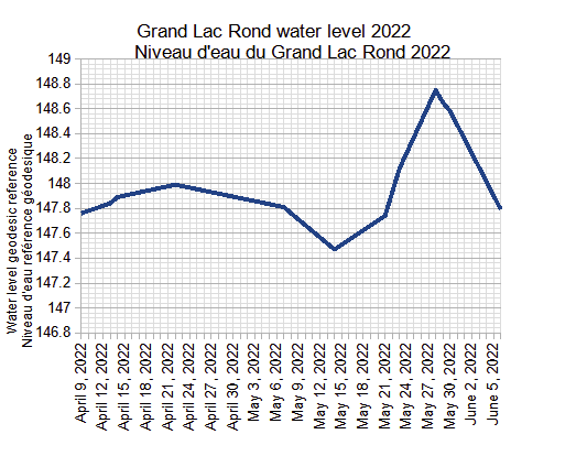
It would be interesting to reflect on the instability of the water level of Grand Lac Rond following recent events. For example, I believe that a permanent water level measurement station on our lake could alert the CEHQ of situations where the water level required intervention by the Lac des 31 Milles dam. I also believe that a weir-dam in the outlet stream flowing into the Gatineau River is necessary to conserve water at Grand Lac Rond during periods of drought when the water level drops. (I don't believe this would have a negative effect on the current flood.) But I am not an expert in this area and it would require decisions from the responsible authorities.
May 31, 2022 (click to see the report)
Since my last report on May 23, the water level of Grand Lac Rond has risen 63 cm (25 inches) to 148.75 m, and then began to slowly decrease. The water level of Grand Lac Rond was at 148.58 m yesterday. It is unbelievable and shameful. For more information regarding this situation, please read my attached report.
It is important to note that the water level of the lake is higher than in 2017 and 2019 when there were heavy floods in the region.
- May 27 8 inches (20.3 cm) taller
- May 26 1 inch (2.54 cm) taller
- May 25 1 1/2 inch (3.8 cm) taller
- May 24 6 inches (15.24 cm) taller
Monday May 23
5:01 p.m.
Since my last report on May 15, the water level of Grand Lac Rond has increased by 65 cm (25.5 inches). The lake is heavily flooded as in 2017 and 2019. Its water level is at 148.12 m and it is rising rapidly. (This morning May 23, in the space of four hours - between 9 a.m. and 1:30 p.m. - the water level rose 5 cm.)
The main reason for the increase in water levels was due to the flow from the Mercier Dam and the high water levels of the Gatineau River. Rising water levels in the Gatineau River slowed the flow of Grand Lac Rond causing the lake to flood. The flow upstream of Lac des 31 Milles has been slowed to prevent further flooding. And fortunately, the Grand Lac Rond was spared the precipitation of the storm that ravaged Ottawa-Gatineau. But the situation is critical and I believe that the water level will continue to rise in the coming days.
I don't know if it is relevant now to compare the water level at Grand Lac Rond with the same period in previous years, but here it is:
-
May 23, 2022 - 148.12 m (and rising rapidly)
-
May 21, 2021 - 147.22 m
-
May 16, 2020 - 147.28 m
-
May 23, 2019 - 148.58 m (the year of heavy flooding)
-
May 22, 2018 - 147.43 m
-
May 20, 2017 - 148.38 m (the year of heavy flooding)
-
May 22, 2016 - 147.39 m
-
May 23, 2015 - 147.30 m
The situation is very dangerous at Grand Lac Rond and with the precipitation forecast later in the week, it is likely to get worse. It will be very important to receive a clear report on the reasons for the flooding, as the snowfall during the winter of 2021-22 (235 mm) was much lower than that of 2018-19 (291 mm) or 2016-17 (295mm).
2:09 p.m.
In the space of four hours today, the water level of Grand Lac Rond has risen again, this time by 5 cm.
At 9 a.m. this morning, the water level was at 148.07 m, and at 1:30 p.m., it was at 148.12 m.
This weekend, the water level rose 38 cm (15 inches).
The state of the lake is critical and dangerous. I don't know the water level of the Gatineau River near Lanigan Island. But if the Gatineau River enters the lake, the results can be catastrophic.
Unfortunately this is my last measurement for a few days. I'm afraid the water level will rise even more. For the 400 residences around the lake, it is very discouraging and dangerous.
11:35 a.m.
The water level at Grand Lac Rond continues to rise dramatically. This morning at 9 a.m., it has gone up 18 cm (7 inches) since yesterday afternoon! The level of the lake is at 148.07 m. It is completely flooded and in a dangerous situation for local residents.
Lac des 31 Milles has risen by 1 cm since yesterday and the discharge has decreased.
Unfortunately I don't know if I could do another water level measurement for a few days.
Sunday, May 22
4:20 p.m.
As I mentioned this morning at 10:30 a.m., the water level had risen 7 cm (3 inches) since the day before.
This afternoon at 4 p.m., the water level has risen 8 cm (3 inches) since this morning.
The water level of Grand Lac Rond is now at 147.89 m. It has increased 25 cm (9.8 inches) since Saturday May 21, and 42 cm (16.6 inches) since last week.
If the water level continues to rise at the same rate, there will be a huge flood at Grand Lac Rond (possibly stronger than the floods of 2017 and 2019).
12:50 p.m.
The water level of Grand Lac Rond continues to rise. Since yesterday afternoon, the water level has increased by 7 cm (3 inches). It is now at 147.81 m. My son took the measurement this morning and he pointed out that there was no rush at the chalet yesterday! The CEHQ stopped the flow of the dam at Lac des 31 Milles to try to prevent the water level from rising.
May 21, 2022 - Possible flooding. The Center d'expertise hydrique has been informed by our Association of the impact of the rising water level of the Gatineau River on the residents of the lake. We have been informed that the situation is being closely monitored. At 3:37 p.m. the Center contacted us again to advise us that the flow of the Hubert-Tremblaty dam would be reduced in the following hour, which will reduce the entry of water into our lake from lake 31 miles.
On the same day Michael Lukyniuk made the following observation:
- The water level of Grand Lac Rond has increased dramatically since last week despite only having 7.9 mm of precipitation. The reason seems to be due to the high flow rate of the Mercier dam. The water level of Grand Lac Rond has increased by 27 cm (11.5 inches) from 147.47 m to 147.74 m since May 14. It is extremely high. During the same period, the Lac des 31 Milles increased by 5 cm. Until the water level of the Gatineau River drops, it is essential that little or no spillage from Lac 31 Milles enters Grand Lac Rond or there could be extreme flooding. My son will try to continue measuring the water level, but due to the high levels it may become difficult or even impossible.
May 14, 2022 (click to see Michael's detailed report)
Since my last report last week, the water level of Grand Lac Rond has dropped by 34 cm (13 inches). I believe the main reason for the dramatic drop in the water level was due to the lack of rainfall and the reduced flow from the dam. At Lac des 31 Milles, the water level decreased by only 1 cm for the same period.
Although it is good news that the flooding of Grand Lac Rond has disappeared, the speed at which the water level has dropped is surprising. Between April 14 and May 14, the water level dropped by 52 cm (20.4 inches). And only between the 12th and 14th of May, I noticed that it decreased by 4 cm (1.5 inches).
When we compare the water level of Grand Lac Rond with the same period of past years, it is at its normal level:
-
May 14, 2022 - 147.47 m
-
May 13, 2021 - 147.17 m
-
May 14, 2020 - 147.33 m
-
May 16, 2019 - 148.24 m (the year of heavy flooding)
-
May 12, 2018 - 147.84 m
-
May 18, 2017 - 148.33 m (the year of heavy flooding)
-
May 15, 2016 - 147.62 m
-
May 14, 2015 - 147.21 m
-
May 13, 2014 - 147.72 m
May 8, 2022 (click to see Michael's detailed report)
Since my last report on April 24, the water level of Grand Lac Rond has decreased by 18 cm. The water level is still quite high, but I noticed over the weekend that it was dropping rapidly.
When we compare the water level of Grand Lac Rond with the same period of past years, it is higher than usual:
-
May 07, 2022 - 147.81 m
-
May 10, 2021 - 147.13 m
-
May 09, 2020 - 147.47 m
-
May 08, 2019 - 148.24 m (the year of heavy flooding)
-
May 09, 2018 - 147.92 m
-
May 09, 2017 - 148.69 m (the year of heavy flooding)
-
May 08, 2016 - 147.87 m
-
May 09, 2015 - 147.16 m
Here is my first report for the water level of Grand Lac Rond for the year 2022.
The water level of Grand Lac Rond has been high lately which is expected for this time of year. Between April 9 and 14, it rose 13 cm to 147.89 m. (Since yesterday it has risen 5 cm.) The precipitation we have received recently has certainly contributed to this rapid rise in water levels. At Lac des 31 Milles, the water level rose by 5 cm for the same period (from 162.05 to 162.10 m.)
When we compare the water level of Grand Lac Rond with the same period in past years, we can see that it is higher than normal (excluding the two years of heavy flooding):
-
April 14, 2022 - 147.89 m
-
09 April 2021 - 147.56 m
-
April 12, 2020 - 147.95 m
-
April 25, 2019 - 148.36 m (the year of heavy flooding)
-
April 27, 2018 - 147.87 m
-
April 13, 2017 - 148.07 m (the year of heavy flooding)
-
April 16, 2015 - 147.20 m
-
April 12, 2014 - 147.33 m
-
April 14, 2012 - 147.11 m
-
April 15, 2011 - 147.95 m
In my next reports, I will include a more detailed report.
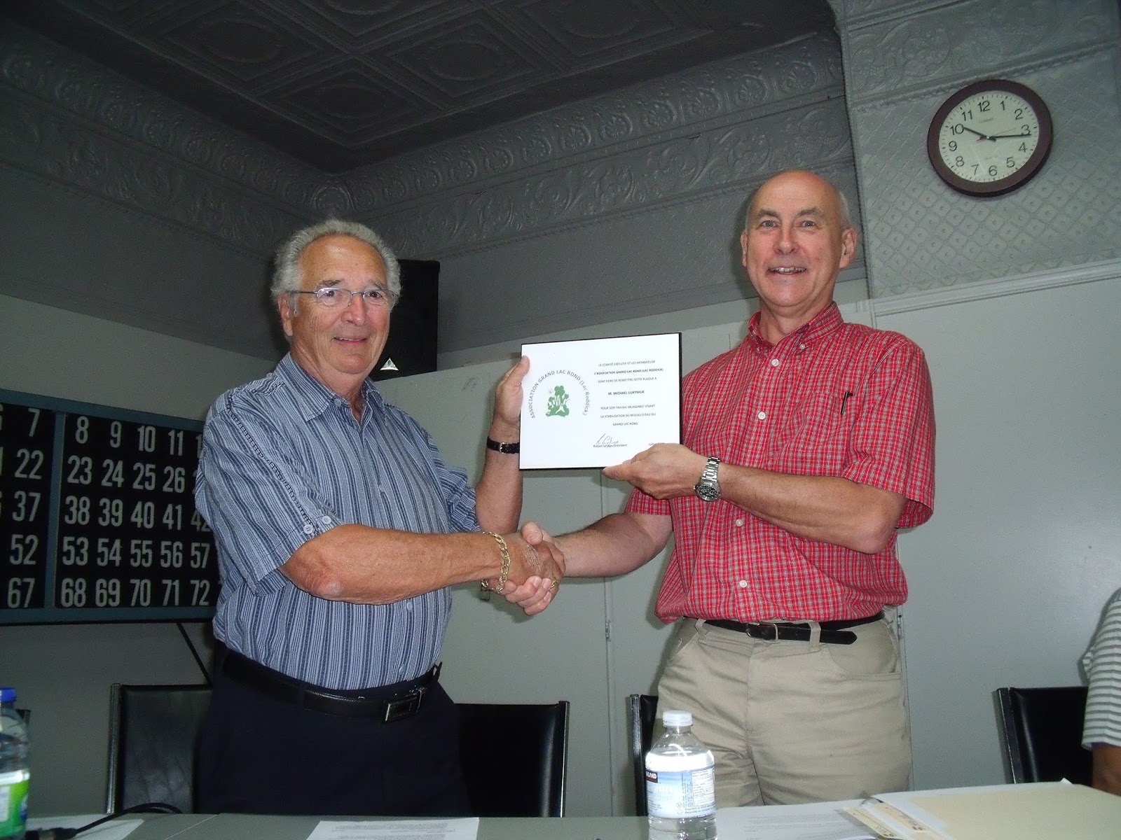
At the Annual General Assembly of 2013, President Robert LeSage presented a plaque to Michael Lukyniuk in recognition of his work to stabilizethe water level of Grand Lac Rond. This recognition was suggested by members at the meeting in July 2012.
THURSDAY, AUGUST 8, 2013
Stabilization of water level